 Out Of The Blue Artifacts A Library of a lifetime of collecting
The Tillery Valley Coal Levels.
In this small area of Abertillery there were quite a few coal levels – Pullingers, Tillery, Olwen, Greenmeadow and the Coronation, later renamed the Wellington Coal Level.
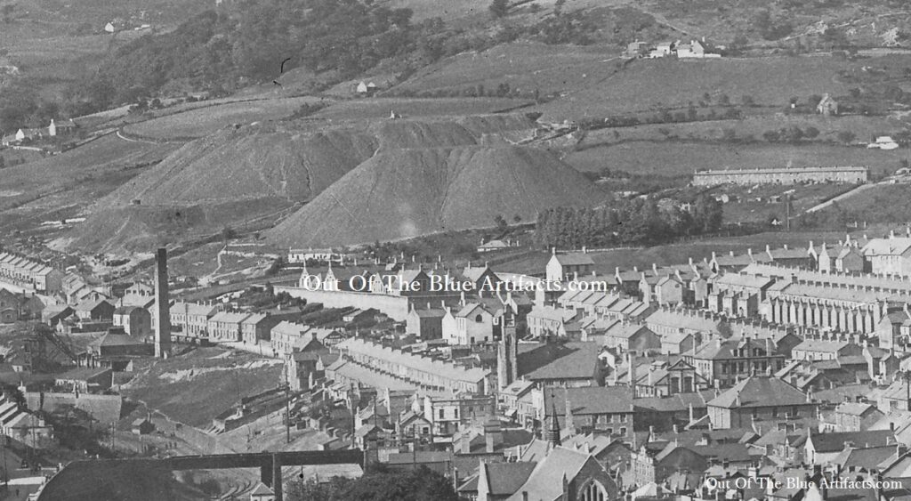
The Tillery Levels were worked in connection with the Penybont Tillery Colliery and was owned by Messrs T. P. & D. Price. The large waste tips can be seen on the image.
Duffryn Level.
The Duffryn Coal Level was a small level in the Duffryn area. It didn’t appear on any lists until 1923 when it was owned by the Duffryn House Coal Colliery Co. Address – 21 Darren Road, Abertillery. They were not listed in 1938.
 The Greenmeadow Level.
The Greenmeadow Coal Level (named after the farm and land close to where the levels were driven).
Messrs Robins, Smith and Coles.
In 1880 the Greenmeadow Level was owned by Messrs Robins, Smith and Coles, though on the 1880 ordnance survey maps they were described as being closed. The 1880 maps may have been compiled before the issue date of 1880, therefore Messrs Robins, Smith and Coles could have restarted the levels at that date, yet the mapmakers hadn’t amended their copies.
The Abertillery Collieries Company.
In 1890 they were owned by the Abertillery Collieries Company of Mr T. Robins Abertillery and Mr Edgar Williams of Crumlin.
In 1896 they were still owned by the same company and were employing fourteen men below ground with four men on the surface.
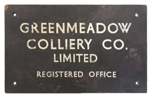
The Greenmeadow Colliery Co Limited.
The level owned by the Abertillery Collieries Company was not listed in 1908 or after. The name plate (above left) shows the Greenmeadow Coal Levels were later owned by the Greenmeadow Colliery Co Limited.
On Wednesday 11th of December 1940, the Greenmeadow Colliery Co Ltd were officially wound-up and notifications of such posted in the London Gazette by Mr A. E. J. Holland (Liquidator) of Messrs Kimpton, Holland & Co, Tredegar Chambers, Bridge Street, Newport. (More information is needed).
Pullingers Level.
The Pullingers Coal Level there is no information listed on this level, it was featured on the old maps but may have opened and closed in between the listings being compiled or taken over and worked by the Abertillery Collieries Company.
The coal taken from these levels were dropped down the same tramway into the Penybont Tillery Colliery for transportation. The waste was just dumped onto the side of the valley close to these levels. The tips were later moved and used to fill in the Cwmtillery Valley during the Land Fill and Reclamation Scheme of the early 1970’s, at which time was the biggest project of its kind in Europe. Later the housing estate of Valley View was built on the land that the tips once occupied.
Points of interest – The image shows the original Foundry Bridge (bottom) constructed by Mr Thomas Gaen who later built and named Gaen Street, Blaenau Gwent along with many other houses in the area. The Gray Colliery (middle left) with Tillery Street originally named Wesleyan Road. The two huge tips from the Greenmeadow and Pullingers Levels dominating the image. The new Wesleyan Church and the Trinity Church. Far right are the cottages of Duffryn Row and at the top Greenmeadow Farm can be seen.