History of the Gwent Collieries

Cwmtillery Old Red Ash Levels

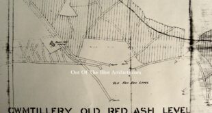
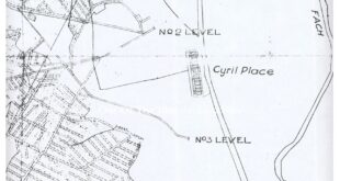
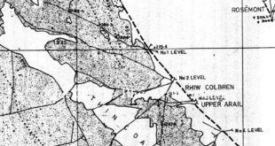
Cwmtillery Old Red Ash Levels. The map shows the six entrances of the Cwmtillery Old Red Ash Level, also the position in relation to Gwastod Farm. This is a small section of a map that is in two sections of 7′ feet long each, showing the whole area of coal mined in this level.

Read More »

Rosemont Coal Level – Clyn Mawr

Rosemont Coal Level – Clyn Mawr. The Rosemont Coal Level was situated on the southern end of Mynydd James just behind the Clyn Mawr Uchaf Farm. It mined coal from beneath the lower part of Mynydd James with the workings extending up past Ty-dan-y-Wal and the Rising Sun to where the Cwmtillery Top Rows were. The Blaina Iron and Colliery …

Read More »

Rosemont Coal Level – Clyn Mawr

Rosemont Coal Level – Clyn Mawr. The map shows the entrances of the Rosemont Coal Level under the lower western part of Mynydd James. It was from these entrances that the coal was brought out and the waste tipped to form the tips behind Attlee Avenue.

Read More »

Rosemont Coal Level – Clyn Mawr

Rosemont Coal Level – Clyn Mawr. The map shows the extent of the Rosemont Coal Level under the lower part of Mynydd James. Also the drift drivage from Cwmtillery Colliery to Rose Heyworth Colliery.

Read More »

Rhiw Colbren Coal Level

Rhiw Colbren Coal Level. This colliery consisted of a series of coal levels numbered 1 to 4, each driven into and under the Arael Mountain from Old Blaina Road. Mr Thomas F. Salt. Owned and opened in the late 1890’s by Mr Thomas Salt of Abertillery. Prior to opening the Rhiw Colbren levels Mr Salt was the manager of the …

Read More »

Rhiw Colbren Coal Level

Rhiw Colbren Coal Level. The map shows the four entrances into the Rhiw Colbren Level and the underground workings in the Red Ash coal seam. Also, the houses of Cyril Place.

Read More »

Rhiw Colbren Coal Level

Rhiw Colbren Coal Level. The map, a portion of an official N.C.B. abandonment map shows a small section of the Rhiw Colbren underground workings in the Red Ash coal seam.

Read More »

The Rose Heyworth Cwmtillery Cable Belts – East West and the Drift

The Rose Heyworth Cwmtillery Cable Belts – East West and the Drift. The map shows the two cable belts running through the Mynydd James Mountain from Cwmtillery to Rose Heyworth and vice versa. The East West Cable Belt and The Drift Cable Belt. The East West Cable Belt. The East West Cable Belt was about 1,245 yards in length and …

Read More »
error: Content is protected !!